

Champagne Map Bundle
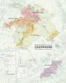
This map bundle forms part of the 'Mapping Champagne' series by Charles Curtis MW and Steve De Long, it's the first modern update and expansion of the pioneering work of Larmat, done in the 1940s. It has a downloadable PDF Index.
These are the most beautiful and up-to-date mapping resource available for the Champagne region.
For those wanting to take their champagne learning to the next level, we have put together a 'bundle' of the maps available in print today, comprising:
Champagne Map - Growing Areas (27 x 34 inches)
Champagne Map - Côte des Blancs (59.0 x 23.625 inches)
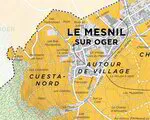
Champagne Map - Le Mesnil-sur-Oger Grand Cru (12 x 15 inches)
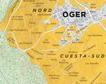
Champagne Map - Oger Grand Cru (12 x 15 inches)
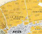
Champagne Map - Avize Grand Cru (12 x 15 inches)
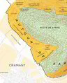
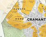
Champagne Map - Cramant Grand Cru (12 x 15 inches)
Champagne Map - Chouilly Grand Cru (12 x 15 inches)
Champagne Map - Vertus Premier Cru (16 x 20 inches)
Printing: Lithograph on 100# (150 gsm) matte coated paper.
By bundling you will save significantly on postage. Also, we will include a complimentary Côte des Blancs Field Guide.